Website Supporters:
Nautical books from:
Members of:
More Nautical books from:
More Nautical books from:
|
Chart Viewer and Navigational Downloads
|
|
PLEASE VISIT OUR SUPPORTERS |
|
|
|
|
 |
|
|
Coast Pilot & Pacific
Chart Catalog Downloads
 |
|
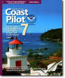
Coast Pilot 7
Covers the coast of California, Oregon and
Washington, between Mexico on the south and
Canada's British Columbia on the north. Coast
Pilot 7 also includes Hawaii and other United
States territories in the South Pacific.
Download
here. Critical
corrections to Coast Pilot 7
here.
|
| |
|
|
 |
|
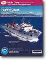
Online Pacific Coast Chart Catalog
Find the correct charts that cover the coasts of
California, Oregon and Washington, between
Mexico on the south and Canada's British
Columbia on the north. The Pacific Coast Chart
Catalog also includes chart coverage of the
Hawaiian Islands.
Access Online Chart Catalog:
Side One
(graphic side)
Side 2 (text
side) |
| |
|
|
 |
|
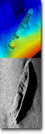
Automated Wreck and Obstruction Information
System (AWOS)
In 1981, the
National Ocean Service (NOS) implemented the
Automated Wreck and Obstruction Information
System (AWOIS) to assist in planning
hydrographic survey operations and to catalog
and store a substantial volume of reported
wrecks and obstructions that are considered
navigational hazards within U.S. coastal waters.
Today, over 10,000 reports have been received,
which include unverified accounts of vessel
casualties, as well as chronological history. As
part of the hydrographic survey planning
process, these records are reviewed and those
wrecks or obstructions which require additional
field investigation are assigned to specific
field units. The results of these investigations
eventually become part of the AWOIS file so that
a permanent record of a wreck or obstruction is
always available.
Search the
AWOS Database
(have area chart number ready)
AWOS
User Guide (.pdf)
|
Pacific Coastal NOAA Nautical
On-line Chart Viewer
Instructions:
Click on a chart number to view that chart. This opens
the chart in a new window, and leaves the list of charts
open in the original window to make further selections.
-
Download NOAA
Nautical Charts
here.
-
Charts on demand
authorized remote printers -
Safe Navigation |
WayPoint |
West Marine
-
UPDATE IN
PROGRESS
SONE CHART LINKS BELOW ARE TEMPORARILY DISABLED
-
Chart links in blue are updated
(at times these charts may be unavailable from NOAA)
|
NUMBER |
SCALE |
TITLE |
|
|
|
|
|
50 |
10,000,000 |
North Pacific Ocean (eastern
part) Bering Sea Continuation |
|
501 |
3,500,000 |
North Pacific Ocean West
Coast Of North America Mexican Border To
Dixon Entrance |
|
530 |
4,860,700 |
North America West Coast San
Diego to Aleutian Islands and the Hawaiian
Islands |
|
531 |
2,100,000 |
Gulf of Alaska Strait of Juan
de Fuca to Kodiak Island |
|
540 |
3,121,170 |
Hawaiian Islands |
|
18003 |
736,560 |
Cape Blanco to Cape Flattery |
|
18007 |
1,200,000 |
San Francisco to Cape
Flattery |
|
18010 |
811,980 |
Monterey Bay to Coos Bay |
|
18020 |
1,444,000 |
San Diego to Cape Mendocino |
|
18022 |
868,003 |
San Diego to San Francisco
Bay |
|
18400 |
200,000 |
Strait of Georgia and Strait
of Juan de Fuca |
|
18421 |
80,000 |
Strait of Juan de Fuca to
Strait of Georgia; Drayton Harbor |
|
18423 |
80,000 |
(Not Available) FOLIO
SMALL-CRAFT Bellingham to Everett Including
San Juan Islands; Blaine |
|
18424 |
40,000 |
Bellingham Bay; Bellingham
Harbor |
|
18427 |
25,000 |
Anacortes to Skagit Bay |
|
18428 |
10,000 |
Oak and Crescent Harbors |
|
18429 |
25,000 |
Rosario Strait - Southern
Area |
|
18430 |
25,000 |
Rosario Strait - Northern
Area |
|
18431 |
25,000 |
Rosario Strait to Cherry
Point |
|
18432 |
25,000 |
Boundary Pass |
|
18433 |
25,000 |
Haro - Strait - Middle Bank
to Stuart Island |
|
18434 |
25,000 |
San Juan Channel |
|
18440 |
150,000 |
Puget Sound |
|
18441 |
80,000 |
Puget Sound - Northern Area |
|
18443 |
40,000 |
Approaches to Everett |
|
18444 |
10,000 |
Everett Harbor |
|
18445 |
80,000 |
(Not Available) FOLIO
SMALL-CRAFT Puget Sound-Possession Sound to
Olympia including Hood Canal |
|
18446 |
25,000 |
Puget Sound-Apple Cove Point
to Keyport; Agate Passage |
|
18447 |
10,000 |
Lake Washington Ship Canal
and Lake Washington |
|
18448 |
80,000 |
Puget Sound-southern part |
|
18449 |
25,000 |
Puget Sound-Seattle to
Bremerton |
|
18450 |
10,000 |
Seattle Harbor, Elliott Bay
and Duwamish Waterway |
|
18452 |
10,000 |
Sinclair Inlet |
|
18453 |
15,000 |
Tacoma Harbor |
|
18456 |
20,000 |
Olympia Harbor and Budd Inlet |
|
18457 |
10,000 |
Puget Sound-Hamersley Inlet
to Shelton |
|
18458 |
25,000 |
Hood Canal-South Point to
Quatsap Point including Dabob Bay |
|
18460 |
100,000 |
Strait of Juan de Fuca
Entrance (includes Metric version) |
|
18464 |
20,000 |
Port Townsend |
|
18465 |
80,000 |
Strait of Juan de
Fuca-eastern part |
|
18468 |
10,000 |
Port Angeles |
|
18471 |
40,000 |
Approaches to Admirably Inlet
Dungeness to Oak Bay |
|
18473 |
40,000 |
Puget Sound-Oak Bay to
Shilshole Bay |
|
18474 |
40,000 |
Puget Sound-Shilshole Bay to
Commencement Bay |
|
18476 |
40,000 |
Puget Sound-Hood Canal and
Dabob Bay |
|
18477 |
25,000 |
Puget Sound-Entrance to Hood
Canal |
|
18480 |
176,253 |
Approaches to the Strait of
Juan de Fuca Destruction Island to
Amphitrite Point |
|
18484 |
10,000 |
Neah Bay |
|
18485 |
40,000 |
Cape Flattery |
|
18500 |
180,789 |
Columbia River to Destruction
Island |
|
18502 |
40,000 |
Grays Harbor; Westhaven Cove |
|
18504 |
40,000 |
Willapa Bay; Toke Pt. |
|
18520 |
185,238 |
Yaquina Head to Columbia
River; Netarts Bay |
|
18521 |
40,000 |
Columbia River Pacific Ocean
to Harrington Point; Ilwaco Harbor |
|
18523 |
40,000 |
Columbia River Harrington
Point to Crims Island |
|
18524 |
40,000 |
Columbia River Crims Island
to Saint Helens |
|
18525 |
40,000 |
Columbia River Saint Helens
to Vancouver |
|
18526 |
20,000 |
Port of Portland, Including
Vancouver; Multnomah Channel-southern part |
|
18527 |
5,000 |
Willamette River-Swan Island
Basin |
|
18528 |
15,000 |
Willamette River Portland to
Walnut Eddy |
|
18529 |
15,000 |
Willamette River Walnut Eddy
To Newburg |
|
18531 |
40,000 |
Columbia River Vancouver to
Bonneville; Bonneville Dam |
|
18532 |
40,000 |
Columbia River Bonneville To
The Dalles; The Dalles; Hood River |
|
18533 |
20,000 |
Columbia River Lake Celilo |
|
18535 |
20,000 |
Columbia River John Day Dam
to Blalock |
|
18536 |
20,000 |
Columbia River Sundale to
Heppner Junction |
|
18537 |
20,000 |
Columbia River Alderdale to
Blalock Islands |
|
18539 |
20,000 |
Columbia River Blalock
Islands to McNary Dam |
|
18541 |
20,000 |
Columbia River - McNary Dam
to Juniper |
|
18542 |
20,000 |
Columbia River Juniper to
Pasco |
|
18543 |
20,000 |
Columbia River Pasco to
Richland |
|
18545 |
20,000 |
Lake Sacajawea |
|
18546 |
20,000 |
Snake River-Lake Herbert G.
West |
|
18547 |
20,000 |
Snake River-Lake Bryon |
|
18548 |
20,000 |
Snake River-Lower Granite
Lake FRANKLIN D. ROOSEVELT LAKE |
|
18551 |
50,000 |
FRANKLIN D. ROOSEVELT LAKE
Southern part |
|
18553 |
50,000 |
FRANKLIN D. ROOSEVELT LAKE
Northern part |
|
18554 |
50,000 |
Lake Pend Oreille |
|
18556 |
20,000 |
Nehalem River |
|
18558 |
50,000 |
Tillamook Bay |
|
18561 |
50,000 |
Approaches to Yaquina Bay;
Depoe Bay |
|
18580 |
191,730 |
Cape Blanco to Yaquina Head |
|
18581 |
10,000 |
Yaquina Bay and River;
Continuation of Yaquina River |
|
18583 |
20,000 |
Siuslaw River |
|
18584 |
20,000 |
Umpqua River Pacific Ocean to
Reedsport |
|
18587 |
20,000 |
Coos Bay |
|
18588 |
20,000 |
Coquille River Entrance |
|
18589 |
40,000 |
Port Orford to Cape Blanco;
Port Orford |
|
18600 |
196,948 |
Trinidad Head to Cape Blanco |
|
18601 |
40,000 |
Cape Sebastian to Humbug
Mountain |
|
18602 |
40,000 |
Pyramid Point to Cape
Sebastian; Chetco Cove; Hunters Cove |
|
18603 |
40,000 |
St. George Reef and Crescent
City Harbor; Crescent City Harbor |
|
18605 |
15,000 |
Trinidad Harbor |
|
18620 |
200,000 |
Point Arena to Trinidad Head;
Rockport Landing; Shelter Cove |
|
18622 |
25,000 |
Humboldt Bay |
|
18623 |
40,000 |
Cape Mendocino and vicinity |
|
18626 |
40,000 |
Elk to Fort Bragg; Fort Bragg
and Nayo Anchorage |
|
18628 |
10,000 |
Albion to Caspar |
|
18640 |
207,840 |
San Francisco to Point Arena |
|
18643 |
30,000 |
Bodega and Tomales Bays;
Bodega Harbor |
|
18645 |
100,000 |
Gulf of the Farallones;
Southeast Farallon |
|
18647 |
40,000 |
Drakes Bay |
|
18649 |
40,000 |
Entrance to San Francisco Bay |
|
18650 |
20,000 |
San Francisco Bay Candlestick
Point to Angel Island |
|
18651 |
40,000 |
San Francisco Bay - Southern
Area; Redwood Creek.; Oyster Point |
|
18652 |
VARIOUS |
(Not Available) FOLIO SMALL
CRAFT CHART San Francisco Bay to Antioch |
|
18653 |
20,000 |
San Francisco Bay-Angel
Island to Point San Pedro |
|
18654 |
40,000 |
San Pablo Bay |
|
18655 |
10,000 |
Mare Island Strait |
|
18656 |
40,000 |
Suisun Bay |
|
18657 |
10,000 |
Carquinez Strait |
|
18658 |
10,000 |
Suisun Bay - Roe Island and
vicinity |
|
18659 |
10,000 |
Suisun Bay - Mallard Island to
Antioch |
|
18660 |
20,000 |
San Joaquin River Stockton
Deep Water Channel Antioch to Medford Island |
|
18661 |
80,000 |
Sacramento and San Joaquin
Rivers Old River, Middle River and San
Joaquin River extension; Sherman Island |
|
18662 |
40,000 |
Sacramento River Andrus
Island to Sacramento |
|
18663 |
20,000 |
San Joaquin River Stockton
Deep Water Channel Medford Island to
Stockton |
|
18664 |
20,000 |
Sacramento River Sacramento
to Four mile Bend |
|
18665 |
40,000 |
Lake Tahoe (Metric) |
|
18666 |
10,000 |
Suisun Bay Middle Ground to
New York Slough |
|
18667 |
20,000 |
Sacramento River Four mile
Bend To Colusa |
|
18680 |
210,668 |
Point Sur to San Francisco |
|
18682 |
20,000 |
Half Moon Bay |
|
18685 |
50,000 |
Monterey Bay; Monterey
Harbor; Moss Landing Harbor; Santa Cruz
Small Craft Harbor |
|
18686 |
40,000 |
Pfeiffer Point to Cypress
Point |
|
18687 |
48,000 |
Lake Mead |
|
18700 |
216,116 |
Point Conception to Point Sur |
|
18703 |
40,000 |
Estero Bay; Morro Bay |
|
18704 |
20,000 |
San Luis Obispo Bay, Port San
Luis |
|
18720 |
232,188 |
Point Dume to Purisma Point |
|
18721 |
100,000 |
Santa Cruz Island to Purisima
Point |
|
18724 |
20,000 |
Port Hueneme And Approaches;
Port Hueneme |
|
18725 |
50,000 |
Port Hueneme to Santa
Barbara; Santa Barbara; Channel Islands
Harbor and Port Hueneme; Ventura |
|
18727 |
40,000 |
San Miguel Passage; Cuyler
Harbor |
|
18728 |
40,000 |
Santa Cruz Channel |
|
18729 |
40,000 |
Anacapa Passage; Prisoners
Harbor |
|
18740 |
234,270 |
San Diego to Santa Rosa
Island |
|
18744 |
40,000 |
Santa Monica Bay; King Harbor |
|
18746 |
80,000 |
San Pedro Channel; Dana Point
Harbor |
|
18749 |
20,000 |
San Pedro Bay; Anaheim Bay
Huntington Harbor |
|
18751 |
12,000 |
Los Angeles and Long Beach
Harbors |
|
18754 |
10,000 |
Newport Bay |
|
18755 |
40,000 |
San Nicolas Island |
|
18756 |
20,000 |
Santa Barbara Island |
|
18757 |
40,000 |
Santa Catalina Island; Avalon
Bay; Catalina Harbor; Isthmus Cove |
|
18758 |
5,000 |
Del Mar Boat Basin |
|
18762 |
40,000 |
San Clemente Island |
|
18763 |
20,000 |
San Clemente lsland - Northern
Area; Wison Cove |
|
18764 |
15,000 |
San Clemente Island Pyramid
Cove and approaches |
|
18765 |
100,000 |
Approaches to San Diego Bay;
Mission Bay |
|
18772 |
20,000 |
Approaches to San Diego Bay |
|
18773 |
12,000 |
San Diego Bay |
|
18774 |
100,000 |
Gulf of Santa Catalina;
Delmar Boat Basin - Camp Pendleton |
|
|